Friday 06 2020

8th century Cave Temple - Kanyakumari


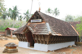
Thirunanthikarai Cave Temple is one of the hundreds of temples that are found in the southernmost region of India. It is a very ancient temple, probably dating to the 9th century AD, that is a symbolic pillar of Indian religion and culture. There are many sculptures inside the temple which are now extinct. The Thirunanthikarai Cave Temple is one of the founding stones of the Jain religion. Currently the Thirunanthikarai Cave Temple is under the purview and care of Archaeological Survey of India. According to research, in 1003 AD, King Raja Raja Chola celebrated his birthday here. He conquered Muttom, and named Mummudi Chola Nalloor as stated in the stone carvings available in the temple. Around the eighth century AD an ascetic named Veeranandi came from Thirunarunkondai Melappalli and stayed here to preach Jainism.


It is one of the most famous and ancient temples of Kanyakumari’ district in TamilNadu, situated on the river banks of Nandhiaaru.  It is believed that it was established in the 9th Century AD and it remains one of the founding stones of Jain religion. The temple was built in the traditional style of Kerala Architecture. Though the temple is the abode of the Lord Shiva, a shrine of Lord Vishnu is also present in the temple facing Lord Shiva. There is an ancient rock-cut cave temple situated towards the northern side of this temple.


Once upon a time, there existed a lot of sculptures inside the temple. Being a famous and ancient temple, many devotees and tourists are greatly attracted.


Although the sculptures are not available at present, there are numerous stone carvings that narrate many interesting tales related to the Indian culture and religion. One of the stone carvings state that King Raja Raja Chola captured Muttom and renamed it as Mummudi Chola Nalloor. According to research, King Raja Raja Chola celebrated his birthday at this temple in AD 1003. This temple served as home to an ascetic named Veeranandi, who preached Jainism during the 8th century.


Thirunanthikarai is a small village situated at Thirparappu in  Kanyakumari district of Tamil Nadu, India. This village is very close to and is located along the Kulasekharam-Pechiparai road. The major cultivation here is rubber plantation and it provides a fine resource of wealth. Most of the people from here speak Malayalam where as a few of them speak Tamil.


Thirunanthikarai has a moderate level of literacy with only one Government School. There exists at Thirunanthikara an Agricultural Co-operative Bank called Thirunanthjikara Agricultural Co-operative Bank. There is also one library called Neethaji Memorial Library run with the aid from the government of Tamil Nadu, serve the people of this locality. It was formed 50 years back.


Thirunanthikara Pond is the major water source of this area that maintains ground water level in the area throughout the year from the Pechiparai Reservoir.


Former Indian Space Research Organisation chairman G. Madhavan Nair was brought up in Thirunanthikara.

Mukaliyadi Hill - Kanyakumari

 Mukaliyadi Hill


Situated on the Western Ghats near Kulasekaram, Kanyakumari this peak is 2146 feet high.  From here, you can see the sprawling Strait 1 and Strait 2 dams.  The Nandiyaru, which originates from Mugali, flows through the Thirunandikarai Nandeeswarar Temple and mixes with the Kothaiyar.The hill is the symbol of Kulasekaram and can be seen anywhere in Kulasekaram.


The mountain ridges and valleys are beautiful.
Ideal place for a mini trip for trekking enthusiasts. The aboriginal people known as the land race have been living in the land of Kurichi for hundreds of years without changing their traditions.  They live in 47 hill villages from Kuvaikadu, Karungali Mudu, Mugaliyadi, Vilsai, Alamparai, Pravilai and Pachamalai in the foothills of West Thotchi, which stretches from Kumai district to Gujarat.


In the copper plate is written the land donated by Mathanda Warma, the king of the kingdom of Travancore, only for the people of the area to cultivate and live in the hills.Artichoke will be the leader of the people of this land.  They are still living according to Evan's orders.  He is on the lookout for a mandate to carry out his orders.  Pilate has land to perform more rituals.


In the past, hunting and their community-based occupations became accustomed to the city dwellers, who gradually came to the cities and began to engage in the business little by little.

After that schools were started in the hill villages and today they working in government and major private institutions.


Wednesday 04 2020

400Year's Old Palace - Kanyakumari


 Padmanabhapuram Palace, also known as Kalkulam Palace, is a Travancore era palace located in Padmanabhapuram in the Kanyakumari district of the Indian state of Tamil Nadu. The palace is owned, controlled and maintained by the government of the neighbouring state of Kerala.

Padmanabhapuram is the former capital city of the erstwhile Hindu kingdom of Travancore. It is around 20km from Nagercoil, 39km from Kanyakumari town and 52 km from Thiruvananthapuram in Kerala.[1] The palace is complex inside with an old granite fortress around four kilometers long. The palace is located at the foot of the Veli Hills, which forms a part of the Western Ghats. The river Valli flows nearby. Another palace known as Kuttalam Palace is situated in Kuttalam in Tenkasi, Thirunelveli district, Tamil Nadu which is also under the ownership of Kerala government. It is situated in the Tenkasi, Tirunelveli District, Tamil Nadu (before state reorganisation, Kanyakumari District, Chenkottah Taluk, Tenkasi Taluk including the areas of Kuttalam are in the control of Travancore Kingdom in Kerala). It is owned, controlled and maintained by the Kerala Government.


The Padamnabhapuram Palace complex has several other interesting features:

  • The palace is located near ThuckalayKanyakumari district of Tamil Nadu state but administered by the Government of Kerala state.
  • The clock tower in the palace complex has a 300-year-old clock, which still keeps time.
  • A big hall now bare, which can accommodate around 1000 guests, and where ceremonial feasts were held, on auspicious occasions.
  • secret passage, now blocked, through which the king, his immediate family members, and their entourage could escape to another palace, located several kilometers away in the event of any emergency. Name of this palace is Charottu Kottaram.
  • A flight of steps leads to a bathing pond, which has lost its freshness due to neglect and years of disuse.
  • The palace complex also has a section of curios and several interesting objects:An entire room filled with old Chinese jars, all gifts by Chinese merchants.A variety of weapons (which were actually used in warfare), including swords and daggers.Brass lamps, wood and stone sculpture, a variety of furniture and large mirrors made of polished metal.A gallery of paintings depicting incidents from the history of Travancore.A wooden cot made of up to 64 wooden pieces of a variety of medicinal tree trunksPolished stone cot, meant for cool effectToilet and well.The palace was constructed around 1601 CE by Iravi Varma Kulasekhara Perumal who ruled Venad between 1592 and 1609. The founder of modern Travancore, King Anizham Thirunal Marthanda Varma (1706–1758) who ruled Travancore from 1729 to 1758, rebuilt the palace in around 1750. King Marthaanda Varma dedicated the kingdom to his family deity Sree Padmanabha, a form of Lord Vishnu and ruled the kingdom as Padmanabha dasa or servant of Lord Padmanabha. Hence the name Padmanabhapuram or City of Lord Padmanabha. In the late 18th century, precisely in 1795 the capital of Travancore was shifted from here to Thiruvananthapuram, and the place lost its former glory. However, the palace complex continues to be one of the best examples of traditional Kerala architecture, and some portions of the sprawling complex are also the hallmark of traditional Kerala style architecture. The Palace though surrounded entirely by the State of Tamil Nadu is still part of Kerala and the land and Palace belongs to the Government of Kerala. This Palace is maintained by the Govt.of Kerala Archaeology Department.

Tuesday 03 2020

Muttom rock beach - kanyakumari


Muttom is a village in the Kanyakumari District of the Tamil Nadu, India. It is a well known for beautiful beach with some rocks and caves. The major occupation of people in Muttom is fishing. Muttom village is attracted by visitors because of its beautiful beach.More than hundreds of people come to the beach every day and spending their time on the beach shore.This beach is known as the best sun set point in the district. Muttom harbor work has been under construction for last 3 years and was expected to be completed before end of 2014.


More than 99% of the village are Christians and they do a variety of jobs. Majority of the people are fishermen who do fishing related works. Most of the people are educated at least to the school level. As most of the residents are Catholics, it has a catholic administration committee which is elected democratically and headed by the parish priest of the All Saints Church.

Muttom has a light house, constructed by the British in colonial times. As recorded in international shipping charts, the lighthouse is situated 110 ft ( 34 m) above sea level . The Skelton was built when India was part of the British Empire until 1947. The British Government started lighthouse construction in 1857 and completed the work in 1882.


Muttom sports a beautiful and tidy beach. Huge rocks standing at either sides of the beach give the beach a pristine look. Since the beach is usually less crowded, it makes an excellent spot for tourists to enjoy its beauty. There is also a children's park.

Monday 02 2020

Peachiparai dam & Island - Kanyakumari


Pechiparai Reservoir is a reservoir located 43 kilometres (27 mi) from the town of Nagercoil, near the village of Pechiparai in Kanyakumari DistrictTamil NaduIndia.The reservoir was formed by the construction of the Jincy Dam, which was built across the Kodayar River about 1 mi (1.6 km) below the confluence of the Kallar, Chittar and Kuttiyar tributaries. It was built during the period 1897 - 1906 by the European engineer, Mr. Minchin,(called as mookanthurai by the local people) during the reign of the Travancore Maharaja Moolam Thirunal.The original cost of construction of the dam was Indian Rupees 216.1 Lakhs (in the late 19th century). The catchment area of the reservoir is 207.19 km2 (80.00 sq mi), and the depth is 14.63 m (48.0 ft). The dam is a straight gravity type masonry dam 425.5 m (1,396 ft) long and 120.7 m (396 ft) high above the deepest foundation. There is no inspection gallery.


The water from the reservoir is used for both irrigation of crops and for drinking purposes, which has led to conflict between farmers who want to use all the water for their crops, and local authorities, who don't have another place to draw drinking water from, for supply to the urban areas. The dam is surrounded by hills of the Western Ghats.


பேச்சிப்பாறை கன்னியாகுமரி மாவட்டத்தில் உள்ள பெரிய அணையாகும். இது தமிழ்நாட்டில் கன்னியாகுமரி மாவட்டத்தில், மேற்குத் தொடர்ச்சி மலையடிவாரத்தில் பேச்சிப்பாறை என்னுமிடத்தில் அமைந்துள்ளது. இது மாவட்டத்தலைநகர் நாகர்கோவிலிலிருந்து 43 கிலோமீட்டர் (27 மைல்) தொலைவில் அமைந்துள்ளது. இவ் அணை கோதையாற்றின் குறுக்கே கட்டப்பட்டுள்ளது. இந்த அணை 1897-1906 காலகட்டத்தில் ஐரோப்பிய பொறியாளர் திரு மிஞ்சின் அவர்களால் அப்போதைய திருவிதாங்கூர் மகாராசா மூலம் திருநாள் காலத்தில் கட்டப்பட்டது.இதன் அப்போதைய கட்டுமானத்திற்காக செலவளிக்கப்பட்ட தொகை 26.1 லட்சம். இவ்வணை கன்னியாகுமரி மாவட்டத்தின் விவசாய மற்றும் குடிநீர் தேவையை பூர்த்தி செய்கின்றது. இவ்வணை மேற்குத் தொடர்ச்சி மலைத்தொடர் அடிவாரத்தில் கட்டப்பட்டுள்ளது. இந்த அணையின் உயரம் முதலில் 42 அடியாக இருந்தது. பின்பு 1964-ஆம் ஆண்டு மேலும் 6 அடிகள் கூட்ட முடிவு செய்து 1969 ஆம் ஆண்டு அணையின் உயரம் 48 அடியாக கட்டிமுடிக்கப்பட்டது. கல்குளம், அகத்தீசுவரம், தோவாளை மற்றும் ராதாபுரம் ஆகிய வட்டங்கள் இதன் மூலம் பலன் பெறுகின்றன. சுமார் 50 ஆயிரம் ஏக்கர் நிலம் இதனால் பாசன வசதி பெறுகின்றது. இதன் நீர்ப்பிடிப்பு பகுதி 207.19 சதுர கிலோமீட்டர்கள் ஆழம் 14.6 மீட்டர்கள் ( 48 அடி). அணையின் நீளம் 425.5 மீட்டர்கள் உயரம் 120.7 மீட்டர்கள் .இங்கு பேச்சியம்மன் பெயாில் சிறு கோயில் ஒன்று கட்டப்பட்டு தெய்வ வழிபாடும் நடைபெற்று வருகிறது.


Sunday 01 2020

Marunthuvazh Malai - Kanyakumari


The Marundhuvazh Malai also known as the Marundhu Vazhum Malai/Maruthwamalai ("the abode of medicinal herbs"),forms the part and the southernmost tip of the Western Ghats of Agasteeswaram taluk of Kanyakumari district. In adjacent lying Southern Kerala people refer to it as Maruthuva Mala.


According to tradition, the Maruthuva Malai is a fragment of the Sanjeevi Mountain, a piece of which fell down here, and it was carried by Hanuman from Mahendragiri to Lanka for healing the fatal wounds of Lakshmana, the brother of Rama, the epic hero. It stretches for more than a km, reaching a height of 800 feet at the highest point. From the highest point of the hill, one can see the 'V'section of the Indian subcontinent . The three Sea(Bay of Bengal, Indian Ocean and Arabian sea) with different shades of blue and coconut trees with different shades of green are visible from this hill. It is about 1 km from pothaiyadi, a place along NH44 and NH66, 10km from kanyakumari entire to Nagercoil.


This hill is also believed to be noted in Ayyaavazhi mythology as Parvatha Ucchi Malai.Apart from the Mythology, this hill is historically related to the life of Vaikundar. So a few theologians consider this hill as sacred and consider it one among the Ayyaavazhi holy sites. Backing some quotes from Arul Nool and Akilam some even argue that Marundhuvaazh Malai is one among the Vaikundapathi's. Narayana Guru attained enlightenment while undergoing penance (tapas) at this hill.

There is a mention about this Marundhu Vaazh Malai in Sri Pada Sri Vallabha Charithaamrutham written during thirteenth century in Sanskrit, which is a biography of Lord Sri Paada Sri Vallabha (first avatar of Sri Dattaatreya). This place is mentioned as Maruthuva Malai and the legend about this mountain is captured. It is also said in the holy book that this is a Holy land and Siddhas and saints live in this Mountain.


Vellimalai temple & Nature - Kanyakumari


 Vellimalai is famous for the Lord Murugan Temple called as "Bala Subramaniya Swamy Koil" located atop of the hill Vellimalai. It is popularly believed that Valli was born here, and raised by a tribal king to marry with Lord Murugan in a Love marriage.Nonetheless, similar story is associated with another namesake place, Vallimalai in Vellore district and Tiruttani of Tiruvallur district in the far north of Tamil Nadu.


Lord Murugan Temple attracts lot of pilgrims from the surrounding areas. The famous festivals of the temple are "Sasti Sura Samkaram"- killing of Suran, the demon leader by Lord Bala Subramaniya Swamy and Vaikasi Visakam. From the top of the hill the major part of the green Kanya Kumari District can be viewed, which will be a mind blowing experience for nature lovers.