Friday 30 2020

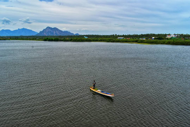
Manakudy backwater & Mangrove forest - Kanyakumari


         Wetland Ecosystem of Kanyakumari district, India

Kanyakumari is the strategic southern tip of India in the bio-hot spot of the Western Ghats, UNESCO Heritage Site and part of the Agasthiarmalai Reserve, which has a rich repository of coastal and fresh water wetlands.

While covering only 6% of the Earth’s surface, wetlands provide a disproportionately high number of ecosystem services, in addition to maintaining biodiversity.

Coastal wetlands are vital for helping to mitigate climate change to manage extreme weather events through the multiple services they provide. Important wetland functions include water storage, groundwater recharge, cyclone protection, flood mitigation, shoreline stabilization, erosion control, and retention of carbon, nutrients, sediments and pollutants.

Presently, wetland ecosystems are severely affected by impacts of climate change such as sea level rise, coral bleaching, hydrological effects, changes in water temperature and alterations in water availability and quality.

Coastal wetlands are nature-based defence that can provide critical protection against cyclone, storm surges.

Mangroves and salt marshes reduce the speed and height of storm surges. Their roots bind the shoreline, resist erosion by wind and waves, and augment resilience against climate change according to Ramsar Convention.

The coastal wetlands of Kanyakumari are critical habitats for local, local migratory and migratory avifauna species, where migratory birds as garganey, shoveller, pintail duck, wigeon, black tailed godwit, pacific golden plover, red shank, green shank and Caspian tern visit from August to December annually. Local birds as greater flamingo, spot billed duck, herons, black winged stilt, open billed stork, white ibis, black ibis, glossy ibis, spoon bill and pelican are found in the wetlands. Ground nesting birds as black winged stilt breed in it.

Considering the rich avifaunal biodiversity the Tamil Nadu Government has declared the Suchindrum-Theroor wetland Complex and the Manakudy Estuary areas as Bird Reserves. To view the birds and to boost eco-tourism, the Kanyakumari Division of the Forest Department has installed watch towers to view the birds by the public and to monitor the birds. Earth mounds have been raised at Theroor lake, Rajakkamangalam lake to enable the birds take rest after a meal. A visitor can see the birds sitting on the mounds and taking rest. Pelican, Open billed stork, white ibis, comorants, darter breed annually in the Suchindrum Wetlands. Two species of the polyandrous Jacana breed in the freshwater wetlands, which build floating nests on water, while painted stork and pelican make local migration to breed in Koonthankulam about 65 kms away.

Many ecologically and economically services are rendered by the wetlands. The Mangroves in Manakudy are a fertile area of fish including crabs, prawns and other inland fish and the fresh water wetlands provide livelihood to many people who earn their living with freshwater inland fish in wetland ponds and lakes. The faunal diversity and abundance of bird species provides immense potentialities for Eco-tourism and Bird Watching and potential areas for researchers for avifaunal study.

Some of the threatening factors to the wetlands are severe encroachment of the banks of the ponds and lakes, pollution by degradable and non-degradable substances, sound pollution created by heavy vehicles and constant traffic, use of chemical based soaps for washing purposes and bathing , illegal leasing of the ponds and lakes for lotus culture, using the wetlands as dump yards, conversion of paddy and agricultural wetlands into residential areas, excessive growth of exotic weeds and non-maintenance of wetlands.

To create awareness to students and the public, Davidson Sargunam, takes them to the wetlands for eco-exposure programs and participatory interactions. He conducts Flamingo Festival each year as part of the sensitization program in Manakudy coastal wetland and conducts photo exhibitions in schools, colleges and to the public on birds for eco-sensitization.


Thursday 29 2020

Happy Birthday kanyakumari Nov 1

The present-day Kanyakumari district of Tamil Nadu state in India was originally a part of the Travancore-Cochin state. Between 1945 and 1956, especially after the Government of India announced plans to reorganize states along linguistic lines, the people of Tamil-majority Kanyakumari campaigned for its inclusion in the Madras State (later Tamil Nadu) instead of the Malayalam-majority Kerala state. In Tamil, the campaign is also known as Therkku Ellai Porattam ("South Frontier Struggle").

The campaign was successful: AgastheeswaramKalkulamThovalaiVilavancode and half part of Shenkottai taluks were merged with Madras as per the States Reorganisation Act, 1956.The first four were combined to form the present-day Kanyakumari district, while Shenkottai was merged with the Tirunelveli district.The central government had appointed Fazal Ali Commission(1953 dec) for the states reorganisation based on language. It submitted its report on 10 August 1955. Based on this report, Devikulam - Peermedu and Neyyattinkara Taluks were merged with Kerala state.

On 1 November 1956 - four Taluks Thovalai, Agastheeswaram, Kalkulam, Vilavancode were recognised to form the New Kanyakumari District and merged with Tamil Nadu State. Half of Sengottai Taluk was merged with Tirunelveli District. The main demand of T.T.N.C was to merger the Tamil regions with Tamil Nadu and major part of its demand was realised. So T.T.N.C was dissolved thereafter.


கன்னியாகுமரி மாவட்ட மக்களின் தாய்மொழி தமிழாக இருந்தாலும் அவர்கள் மலையாள மொழிப் பகுதியாகிய கேரளத்தோடு இணைந்திருக்க விரும்பவில்லை. மேலும், கன்னியாகுமரி மாவட்டத்தின் வளர்ச்சி கேரள அரசால் புறக்கணிக்கப்பட்டது. இந்நிலையில் மார்ஷல் நேசமணி தலைமையில் விடுதலைப் போராட்டம் தொடங்கியது. 1956 நவம்பர் முதல் நாள் குமரி மாவட்டம் தமிழ்நாட்டின் ஒரு பகுதியாக மாறியது.

இம்மாவட்டத்தின் முதல் மாவட்ட ஆட்சியராக திருமலை என்பவர் நவம்பர் 1, 1956 அன்று பொறுப்பு ஏற்றுக் கொண்டார்.


Wednesday 28 2020

Matti banana only for kanyakumari


மட்டி என்பது வாழையின் ஒரு இனம். மட்டி வாழைப்பழம் அளவில் சிறியது. இது கன்னியாகுமரி மாவட்டத்தில் அதிகம் விளைகிறது. இது மற்ற வாழைப்பழங்களை விட இனிப்பு சுவை மிகுந்து காணப்படுகிறது.இதில் மாவுத்தன்மை மிகுதியாக காணப்படுவதால் சிறுகுழந்தைகளுக்கு அதிகம் கொடுக்கப்படுகிறது.

An unique banana “Matti pazham“ predominantly grown in Kanyakumari district, .Nice smell.Awesome taste.

Chitharal Jain Monuments kanyakumari


சிதறால் சமணக் கோயில் (Chitharal Jain Monuments), இதனை உள்ளூர் மக்கள் சிதறால் குகைக் கோயில் என்றும், சிதறால் பகவதியம்மன் கோயில் என்றும் அழைப்பர்.சிதறால் மலையில் சமணக் குடைவரைக் கோயில், கிமு முதல் நூற்றாண்டு முதல் கிபி ஆறாம் நூற்றாண்டு வரை நிறுவப்பட்டதாகும்.

இக்குடைவரைக் கோயிலில் சமண சமயத்தின் மகாவீரர்பார்சுவநாதர் போன்ற தீர்த்தங்கரர்கள் மற்றும் பத்மாவதி தேவதையின் சிற்பங்களைச் சுற்றிலும் யட்சர்கள் மற்றும் யட்சினிகளின் சிற்பங்கள் செதுக்கப்பட்டுள்ளது. தீர்த்தங்கரர்களை வழிபடுவிதமாக அம்பிகைவித்தியாதரர்களின் சிற்பங்கள் உள்ளது.இக்குடைவரைக் கோயில்கள் திகம்பர சமணப் பிரிவினர் நிறுவியதாகும்.முதலாம் மகேந்திரவர்ம பல்லவன் (610-640) காலத்தில், சிதறால் கிராமப் பகுதி, சமணர்களின் செல்வாக்கு செழித்திருந்தது.

இக்குடைவரைக் கோயில் மண்டபம், முற்றம், பலி பீடம், சமையல் அறைகள் கொண்டது. இங்குள்ள மூன்று முக்கிய சந்நதிகளின் நடுவில் மகாவீரர் சிற்பமும், இருபுறங்களிலும் பார்சுவநாதர் மற்றும் பத்மாவதி தேவியின் சந்நதிகள் உள்ளது. இக்குடைக் கோயில் அருகில் இயற்கையில் அமைந்த குளம் உள்ளது. கிபி 13ஆம் நூற்றாண்டில் இச்சமணக் குடைவரைக் கோயிலில், பகவதியம்மனை பிரதிட்டை செய்து இந்து சமயக் கோயிலாக மாற்றப்பட்டுள்ளதாக கருதப்படுகிறது.

முன்னர் இக்குடைவரைக் கோயில் சமண சமயத் துறவிகளின் சமயக் கல்விக் கூடமாக விளங்கியதென இங்குள்ள தமிழ் வட்டெழுத்து கல்வெட்டுகள் கூறுகிறது.

தற்போது இக்குடைவரைக் கோயில் இந்தியத் தொல்லியல் ஆய்வகத்தின் பராமரிப்பில் உள்ளது.

Kodayar secret falls kanyakumari


The forests in Kanyakumari District are about 75 million years old. Of the total district area of 1671.3 km2, government forests occupy an area of 504.86 km2 which comes to about 30.2 percent of the geographical area of the district.[21] The forests of the district are administered through the Kanyakumari Forest Division, with headquarters at Nagercoil, the capital of Kanyakumari District

Location view (Clickhere)


The forests in Kanyakumari District has numerous high trees and large plants. Especially, the Kanyakumari forests has highly grown sandal trees, teak trees, rosewood trees, Wild Jack trees. There are also plenty of herbal plants. These plants, if used properly, can cure many diseases. Several private estates are in the forests. pepper and cloves are grown in large numbers in such estates. Totally the district's forests has some 600 varieties of large trees and another 3500 varieties of small trees.


The major river in the Kanyakumari district is Thamirabarani locally known as Kuzhithurai Aaru (Kuzhithurai River). This river has two major tributaries, Kodhayaru and Paraliyaru, with the Pechiparai Dam and Perunchani Dam, respectively, built across them. There are many tributaries for the Kodayar River of which Chittar I and Chittar II, with their dams, are the major ones. The origin of Tambaraparani River is in the Western Ghats and the river confluences with Laccadive Sea near Thengapattanam, about 56 kilometres (35 mi) west of Kanyakumari town.


Tuesday 27 2020

Hanging Trough Kanyakumari

Mathoor Aqueduct or Mathoor Hanging Trough, The southernmost town of India. It is one of the longest and highest aqueducts in South Asia and is a popular tourist spot in Kanyakumari District. The nearest railway station is Kuzhithurai Railway Station which is about 15 kilometres away and the nearest airport is the Trivandrum International Airport which is about 70 kilometres away.

location view (clickhere)


Mathoor Aqueduct was constructed in 1966 by the then Chief Minister of Tamil Nadu,Honorable Chief Minister Kamarajar , as a drought relief measure across the river Pahrali. Its purpose is to carry water for irrigation from an elevated level of one hill to another. The irrigation water feeds the taluks of Vilavancode and Kalkulam.


The aqueduct is built across the Parali river, a small river that originates in the Mahendragiri Hills of the Western Ghats. Mathoor Aqueduct itself carries water of the Pattanamkal canal for irrigation over the Parali, from one hill to another, for a distance of close to one kilometer. This aqueduct is needed because of the undulating land terrain of the area, which is also adjacent to the hills of the Western Ghats.

Mathoor Aqueduct is a concrete structure supported by 28 huge pillars, the maximum height of the pillars reaching 115 ft. The trough structure is 7 ft in height, with a width of 7.5 ft. The trough is partly covered with concrete slabs, allowing people to walk on the bridge and to see the water going through the trough. Some of the pillars are set in rocks of the Pahrali river, though some of the pillars are set in hills on either side.

There is road access to one end of the aqueduct and to the foot of the aqueduct (the level where the Pahrali flows) on the opposite side. There is a huge flight of stairs, made more recently, that allows one to climb from the level of the Pahrali river to the trough.

Irrigation water flows through the trough for a large part of the year, except in the summer (from February to May).


In recent times, Mathoor Aqueduct has become a popular tourist attraction in Kanyakumari District. The tourism department and the local 
Panchyat office have improved facilities for visiting tourists.From the centre of the aqueduct, one can see a vast expanse of greenery, with rolling hills of the Western Ghats in the background, and the meandering Pahrali river flowing below.

Mathoor Aqueduct is about 60 km from the popular tourist town of Kanyakumari and about 60 km from the city of Trivandrum, the capital of Kerala state.

Monday 26 2020

Dragon fish 100million year


Meet Aenigmachanna gollum, a dragon snakehead fish that lives in underground aquifers, and which first announced its surfacing in social media posts in 2018. It looks like a dragon, swims like an eel, and has remained hidden for a hundred million years.
 

Thirparappu Water falls - Kanyakumari

Location View (Clickhere)

Kanyakumari has much to offer to sightseers for the sake of attractions. Thirparappu Falls is one such vacation spot where sightseers can appreciate some awesome time near nature. Thirparappu Falls is a standout amongst the most famous vacation spots of Kanyakumari


Best Time To Visit : A casual visit to Thirparappu Falls is full of fun and merrymaking. People enjoy spending a good time in the cool waters of this waterfall. Interestingly, the waters remain cool during the whole year. Though it can be visited during any time of the year, the best time for witnessing its real beauty lies in monsoon. The flow and the width of this waterfall double up and make it appear even charming. 


Reaching There : With a well-established network of the roadways and railways, it has become easier to reach Thirparappu Falls. The local transit plies till the village of Thirparappu and from the from there, one can hire horse carts to reach the waterfall.

Nearest Railway Station- Thiruvananthapuram Railway Station.